Big Travel Survey
Tell Us About How You Travel in Leicestershire
- Learn how, why, when and where people travel across Leicestershire
- Understand what makes travel easier or more difficult
- Identify barriers that prevent people from accessing essential services like healthcare, education, shops and leisure activities, as well as work places
Everyone’s travel experience is different – and that’s why your input is so valuable. No matter your mode of transport – we want to understand what works well and what could be better for you.
We’re also keen to learn about any challenges you face; such access to services, and work places. Your feedback will help us shape future plans that support more inclusive travel across Leicestershire.
Taking part is simple, and your information will be kept confidential. Every response helps us make better decisions for our communities.
- The map comes preloaded with several layers of information. To choose the layers you want to see, simply click on the 'layer' tab in the top left corner of the map, and from the drop down menu switch the layers off and on.
- You can add a marker on the map and as with layers, you can select the markers you want to see by clicking the marker tab in the top left corner of the map and choose your selections from the drop down menu. Click on the "add marker" button located in the lower right corner to place your marker in the required location. Please note, you can add more than one marker.
- When viewing the map you have the ability to scroll in and out and you can make the map larger by clicking the arrows in the top right corner of the map
Complete Leicestershire's Big Travel Survey below
Guide: How to use the big travel survey map.
Guide contents:
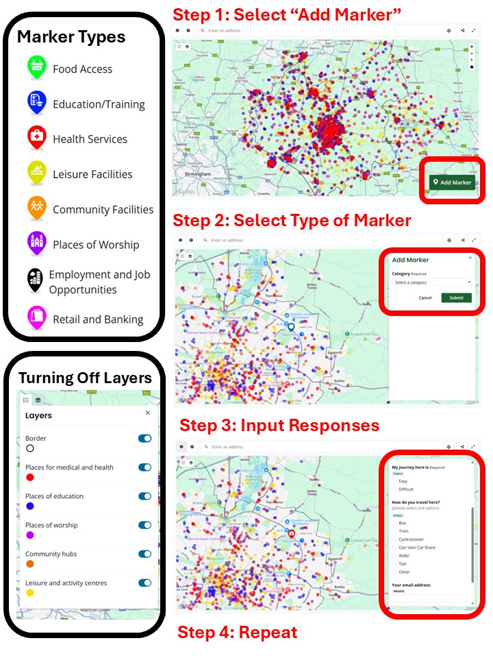
- How to add a marker infographic
- Tools available to help you use the map.
- Add your marker.
- Layers information.
- Additional help using the map.
How to add a marker - infographic
Tools available to help use the map.
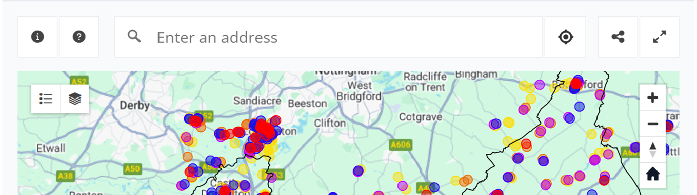
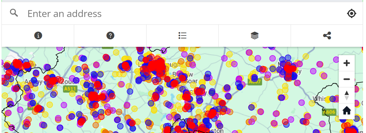
Once you close the big travel survey textbox, which is open when you first visit the map. The top section of your map should look like image 1, below if you are on desktop, or image 2 if you are on mobile or using a high zoom:
- Image 1: desktop/laptop computer tool bar, below.
- Image 2: mobile/tablet and zoomed in computer, below.
Each button or tool available within the image above is explained below:
| Info icon |
| If the “Big Travel Survey” text box is closed and you would like to see it again click the info tool, it is displayed as a (ℹ️) symbol in the top left corner, an enlarged version of the symbol is displayed to the left. |
| Instructions icon |
| Clicking/tapping this icon opens a different text box which
provides instructions in a different format explaining how to use the map. |
| Address Search tool | You can use this tool to navigate through the map, via addresses, rather
than clicking pinching or zooming the map. | |
| Categories filter |  | Clicking/tapping this tool displays the different categories, that are also displayed when the Info icon is clicked/tapped, however you are able to turn off and on which markers are displayed on the map, this can be used to make the map easier to navigate. There is further information on this tool in the add your marker section of the guide |
| Layer filter |  | This tool can be used to turn off the pre-loaded map layers.
There is more information on this tool in the layers information section |
| Your current location |  | Clicking/tapping this tool zooms the map to your current
location allowing you to navigate the mapping portal easier. |
| Share tool |
| Clicking/tapping this tool allows you to send a link to your
contacts, this tool varies based upon the type of device, operating system/user
interface you are using. |
| Full screen too |
| (not available within
mobile versions) Clicking this tool will open the map in a larger window, to
undo this click the button again. |
| Zoom in/ Zoom out |  | Clicking/tapping the ( – ) zooms
the map out, Clicking/tapping the (+) zooms the map in providing more details. |
| Compass icon |  | If you have rotated or angled the map in any way clicking/
tapping this tool will realign the map northwards |
| Home icon |  | No matter where you are located or the level of zoom in or zoom out, clicking/tapping this tool will bring the map back to its default position. |
| Add Marker Button |  | This is the most crucial aspect of the big travel survey map
engagement and consultation. It is with this tool that you will be able to
inform Leicestershire County Council of difficulties you experience in
travelling to your destination within Leicestershire. |


Add your marker
After clicking/tapping the Add Marker Button, the following symbol will be displayed:
| Marker Silhouette (left) |
| Blank Marker (left) |  |

- For desktop: your cursor (whilst hovering over the map) will change to the marker silhouette above.
- After clicking in a location before selecting a marker category the blank marker will appear.
- Tip, if you click and drag you will not enter the category selection step.
- For mobile: the blank marker symbol below will be placed within the centre of your map allowing you to either search the location within the address search tool, or pull and adjust the map until the blank marker is placed over the desired location.
Once you have found your desired location click/tap again (without dragging or holding the click/tap only a single click) and the following window will open.
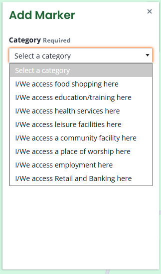
Marker categories:
| I/We access food shopping here (supermarkets, convenience stores,
grocers, foodbank, deli, farm shop.) |
| I/We access education/training here (schools, colleges, university, training centre, preschool, school-run.) |
| I/We access health services here (GP, clinic, dentist, hospital, pharmacy.) |
| I/We access leisure facilities here (leisure centres, spa, gyms, hotels, swimming pools, sports, restaurants, pubs, venues, entertainment.) |
| I/We access a community facility here (village halls, libraries, parks, green spaces, cultural centres, youth centres, family hubs, childcare, job centres.) |
| I/We access a place of worship here (E.g. Church, Synagogue, Mosque, Gurdwara, Temple, multi-faith space.) |
| I/We access employment here (your place of work.) |
| I/We access Retail and Banking here (Clothing, banking, post office, shops, |


Once a category is selected a form will appear within the add marker text box, the form appears as below.
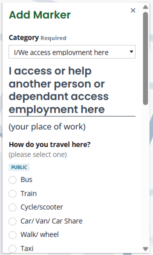
There is only one required answer per marker form:
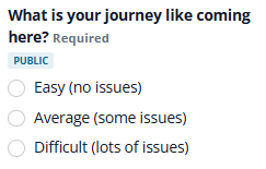
All other questions may be left blank if that is how you would like to respond. However, all answers provided will be reviewed so you are encouraged to provide as thorough responses as possible.
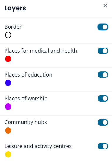
Layers information
As can be seen with the first look at the map section there are many dots placed across the map. These dots are layers of information within the map that can be used to identify specific locations.
Using the layer filter, you can choose what layers are active, and subsequently turn off and on the layers which are most relevant to yourself. The layers available are:
Additional Help using the map
If you would like assistance to help you use this map tool, please attend one of the workshop events detailed within the ‘Events supporting the survey’ tab. Alternatively contact choosehowyoumove@leics.gov.uk for further information or advice.


